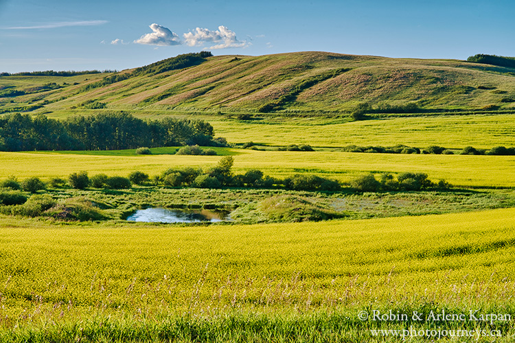
This route goes through some of the most scenic parts of the Thickwood Hills northeast of The Battlefords, and includes one of Saskatchewan’s most unusual natural phenomena—the famous Crooked Bush. We get there along Burma Road, and with a name like that you just know it has to be a great drive. The roads are mostly good gravel, with some pavement. A few short sections might be “iffy” in wet weather, but they can easily be avoided with short detours.
We describe the route as a loop trip starting and finishing in The Battlefords, but it could easily be adapted to start anywhere in the region. Parts of it could also be combined with portions of the route described in our previous post, Thickwood Hills Scenic Drive – Highway 378, which also goes through the Thickwood Hills but along different roads.
Burma Road
Take Hwy 40 east of North Battleford towards Hafford and Prince Albert. About 27 km east from the edge of the city, Hwy 40 curves to the south. At this corner, a sign points the way north to Burma Road, a major gravel grid road. Almost immediately the road descends into a valley with marvelous views, then winds its way past wetlands, farm yards, and wooded hills. After going for about 6.5 km in a northeasterly direction, the road curves and heads straight east. It’s just 8 km (5 miles) farther to the junction with Road 376 between Richard to the south and Mayfair to the north.
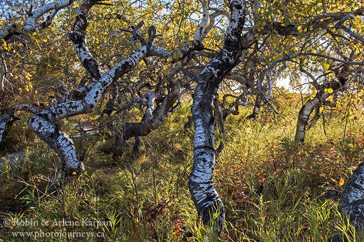
To get to the Crooked Bush, cross Road 376 and continue east another 11.2 km (7 miles). Then go north for 6.4 km (4 miles), and west for 0.6 km (there are signs pointing the way). The Crooked Bush is on the south side of the road; watch for a gravelled approach and parking lot. In order to protect this special grove, stay on the boardwalk and do not climb on or disturb the trees in any way.
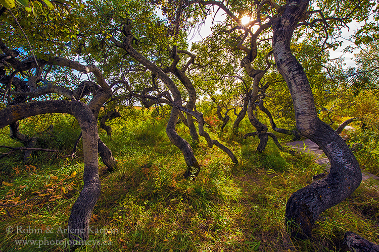
A Twisted Tale
To call the trees “crooked” is an understatement. The small bluff of aspen trees seems like the set for a horror movie, with strangely contorted trunks and branches twisting in all directions—not the kind of place you want to be at midnight during a full moon.
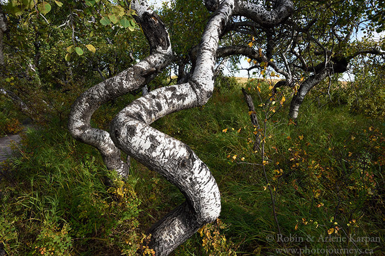
Most fascinating is that every tree in this bush is contorted while trees in neighbouring bushes grow normally. That all trees in a bush are similar is not unusual, since aspens reproduce through a suckering system, so whatever happened to the parent plant has also been passed on to the offspring. Take a walk along the driveway on the south side of the bush, where numerous tiny new trees are already contorted. What is unusual, however, is that this strange occurrence happens here and nowhere else. While tree twisting has been reported in other parts of the world, it seems rare with aspens.
Possible causes for the phenomenon have led to some colourful speculation over the years. Someone suggested that they must have buried a lawyer here. Then there’s someone who claimed that he saw a UFO land here. The inhabitants got out of the craft, all peed on the ground, then got back in and flew off. The trees were never the same after that. Scientists, spoilsports that they are, have more mundane explanations involving mutations or genetic defects. So, as you gaze over this other-worldly scene, feel free to speculate, let your imagination run wild, and come up with your own conclusions. Perhaps it was spaceman pee that caused the mutation in the first place.
Back to The Battlefords
From the Crooked Bush, go east for 0.6 km to the first crossroads. If conditions are dry, continue east along the minor road for 3.2 km (2 miles) to the Alticane Road, a major north-south grid road. In wet conditions, or soon after a rain, it’s best to avoid this stretch. Instead, head 3.2 km (2 miles) south to the next gravel road, then travel the 3.2 km east to the Alticane Road.
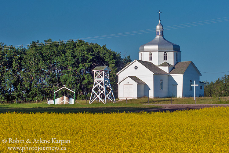
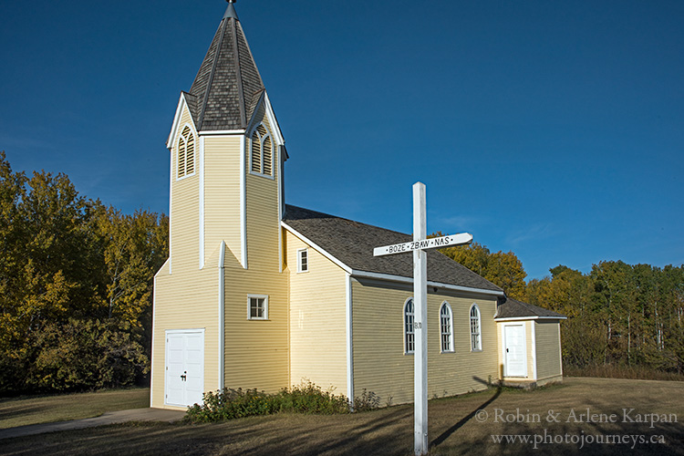
Travelling north, you first pass the entrance to the tiny community of Alticane then gleaming white St. John the Baptist Ukrainian Catholic Church a few kilometres farther. Just 3.2 km north is another old church, St. Joseph’s, dating to 1935.
Alticane Road ends at the T-intersection past St. Joseph’s Church. Turn west and follow the gravel road for 8 km or so to the village of Mayfair. From Mayfair the road continuing west is Hwy 324, which is paved but almost always rough. Follow 324 as it heads west then south where it drops into a wooded valley. While attractive anytime, the view along here ranks among our favourite spots in the region for fall colours.
Just past the valley, Hwy 324 makes a sharp turn west then starts climbing into the hills. After about 8 km from the corner, it ends at the junction with Hwy 378, running between The Battlefords and Spiritwood. This road is the most direct route to The Battlefords, and was described in the last post Thickwood Hills Scenic Drive – Highway 378. It’s an excellent road to take (for scenery, not necessarily for the quality of the road). However, Road 750 is also a great alternative.
Road 750 to Hwy 4
From the junctions of Hwys 324 and 378, continue west for just over 3 km to where 378 makes a sharp turn south towards Whitkow. Instead of turning keep going west on Road 750, a major gravel road. You can follow it all the way to Hwy 4 as it winds through beautiful hilly scenery with superb views all around. It meets Hwy 4 roughly 15 km straight north of The Battlefords.
If you like get even more off the beaten path, explore some of the side roads off Road #750. One area we like is around Scent Grass Lake, an important migratory bird sanctuary which always seems to have a lot of bird activity in the adjoining marshes. About 16 km west of the junction with Hwy 378, a prominent hill looms just to the north of Road 750, with Scent Grass Lake just to the west of it.
We describe this route in more detail complete with maps and GPS coordinates in our popular guidebook Saskatchewan’s Best Scenic Drives.
SUBSCRIBE to Photojourneys below
Feel free to PIN this article

Beautiful pictures! I went to Crooked Bush last year and even though it’s just a small patch of trees, it was worth visiting!
We’re glad you enjoyed your visit.
We went to the Crooked Bush area many years ago. Amazing, but for some reason it almost freaked me out- scary.
Thanks for your comment Blaine. It is a scary looking place.