Saskatchewan is justifiably famous for having the most dazzling sunrises and sunsets on the planet, with the Land of Living Skies putting on a show practically anywhere we go. But to kick things up a notch, check out these easily accessible vantage points to watch the sun do its magic.
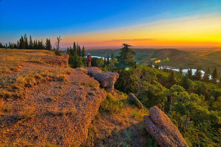
The Conglomerate Cliffs in Cypress Hills Interprovincial Park

The Conglomerate Cliffs in Cypress Hills Interprovincial Park consist of small, round rocks with a reddish tinge, cemented together through a natural process over the course of eons. They face east over a forested valley slope, with Adams Lake below and a backdrop of rolling grasslands. While magnificent any time, sunrise in summer can be a grandstand event. Hills to the east are lower than the cliffs, so when the sun clears the horizon it shines up at the cliffs, bathing them in a crimson-red glow.
Getting there
After entering the park’s West Block from Highway 271 southwest of Maple Creek, keep going west until you see the sign for the Conglomerate Cliffs.
Bald Butte and Lookout Point – Cypress Hills Interprovincial Park
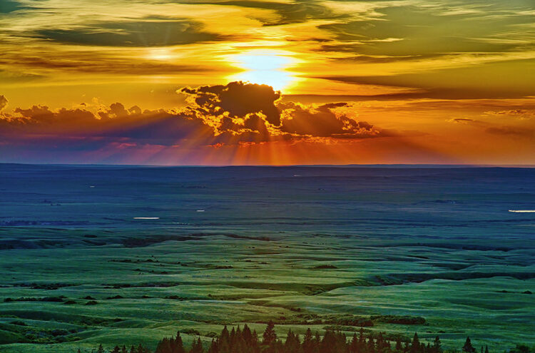
Almost next to each other, Bald Butte and Lookout Point are the most convenient sunset spots in the Cypress Hills, just a few minutes’ drive from the core area of the park’s Centre Block. From the edge of the escarpment on the appropriately named Lookout Point, we gaze north over the mostly open plains some 600 metres below. The town of Maple Creek looms 30 kilometres away, and on a clear day it’s easy to imagine that we really can see forever.
Less than a kilometre farther down the road we come to Bald Butte, one of the highest points in the Centre Block. The short walk from the parking area to the top of the rounded, mostly treeless hill gives us sweeping views to the north and west towards the hills of the park’s West Block. From the top, we watch as backlighting from the setting sun hits the mix of green hills, forest, and wildflower-speckled grasslands.
Getting there
From the park’s core area, follow Bald Butte Road to both vantage points.
Castle Butte – Big Muddy Badlands


This spot will have you seeing red. The glacial-carved Big Muddy Badlands have been scoured and sculpted for thousands of years, leaving a labyrinth of coulees and revealing multi-hued layers on eroded hills. The most impressive and easily accessible part of the valley is Castle Butte, an imposing 60-metre-high monolith that has been a prominent landmark for years.
As the sun nears the horizon, the butte takes on increasingly warm tones just before sunset. Sunrise is even better. In summer, as the sun comes up over the lowest part of the valley floor, it immediately shines up at the monolith, turning it fiery red.
Getting there
Travel south of Bengough on Highway 34 for about 15 kilometres, then turn west at the sign for the scenic butte. The site is open June 1 to November 1 each year and closes for the winter and spring months.
Prospect Point – Prince Albert National Park
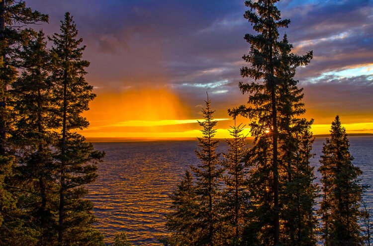

Whenever we stay in or near the Waskesiu townsite in Prince Albert National Park, Prospect Point is our favourite spot for sunset. This prime lookout faces west over Waskesiu Lake and the setting sun. Welcoming benches make it easy to relax and enjoy the show. Changeable summer weather can bring very different sunsets from one day to another.
Getting there
From the townsite, head west on Lakeview Drive to the large parking area where the road starts to curve at the top of the hill.
Lookout Point – Saskatchewan Landing Provincial Park


Lining both the north and south shores of Lake Diefenbaker, Saskatchewan Landing Provincial Park has a wonderful mix of natural prairie, rugged hills and shoreline. Most important for sunset seekers: great vantage points to take it all in during the best light.
Getting there
The top go-to spot is simply called the Lookout Point, west of Highway 4 on the north shore, along the road to the park’s beach. From a beautifully situated bench high on the valley rim, we look over the hills and coulees of Brunyee Ridge on the south shore, and up and down the lake.
Lake Diefenbaker – Near Prairie Lake Regional Park

With 800 kilometres of scenic shoreline, Lake Diefenbaker abounds in amazing spots for sunrise or sunset. One that stands out is the approach to Prairie Lake Regional Park on the north shore. Near the lake, the road winds down the valley slopes. The mix of hilly green pastures and glimpses over the water is especially stunning in the golden hour light before sunset. Near water level, it gets even better. On a clear evening just before sunset, the shoreline cliffs sometimes take on striking orange-red tones.
Getting there
Head south of Beechy on Highway 342. Just outside town, turn southeast at the sign to the park.
70 Mile Butte – Grasslands National Park

Rising 100 metres above the valley floor, massive, flat-topped 70 Mile Butte is an iconic landmark of Grasslands National Park. Named for its location, the butte was 70 miles from Wood Mountain Post and 70 miles from East End Post along the old North West Mounted Police patrol trail. Today it is most famous for the outstanding hiking possibilities, including a trail to the top for a 360-degree view over the Frenchman River Valley and surrounding countryside.
The lower terrain west of the butte provides some great opportunities to watch the setting sun cast its spell.
Getting there
To get to our favourite spot, travel south of Val Marie on Highway 4 for about five kilometres to where the highway curves west. From this corner head south on the gravel road then turn east at the sign for Two Trees Trail. The road crosses high ground with excellent vantage points over 70 Mile Butte and the Frenchman River Valley in the foreground.
Rock Creek Badlands – Grasslands National Park


Saskatchewan has some amazing badlands, though the Rock Creek Badlands are the baddest of them all. From the valley rim we look over a wild land of isolated buttes, weathered outcroppings, eroded gullies, steep hillsides, hoodoos and wooded coulees. Colours ranging from coppery browns to rusty reds, shades of gold, and creamy whites come alive in the golden hour just after sunrise or just before sunset. Enjoy these views from several vantage points along the Badlands Parkway.
Getting there
The Badlands Parkway (11 km one-way) starts near the entrance to the Rock Creek Campground and Day Use Area in the park’s East Block.
Jones’ Peak – Frenchman River Valley

One of the most beautiful stretches of the Frenchman River Valley runs west from the town of Eastend. The highest point on the valley rim is Jones’ Peak, conveniently marked by a communications tower. Come here before sunset and look over the valley to the south as it takes on the rich colours of this magical time.
Getting there
From Eastend, take Grid Road 614 west and north for about four kilometres. Where the road climbs out of the valley, take the first road west (Middle Bench Road). After about seven kilometres, turn south to the tower on Jones’ Peak.
The Great Sand Hills


Landscapes anywhere look their best during golden hour light, but sand dunes have a special quality in those minutes before the sun sets. During the day, the colour of sand is…well, sandy. But when the sun dips low in the sky, the transformation can be dramatic, giving the sand a golden or reddish glow, depending on light conditions. The most convenient place to experience this is the Great Sand Hills where we can drive right up to the dunes.
Getting there
Start at the village of Sceptre, home to the Great Sandhills Museum. From the east side of town on Highway 32, follow the well-signed route south to a parking area next to the sand dunes.
I would love to see Grey Owls cabin and also drive the whole highway 13.
These glimpses of a most unusual landscape are most intriguing and make the traveler’s feet itch.
Thanks for your comments Laura and Canute.