
Although Hwy #11 is the quickest way to drive between Saskatoon and Prince Albert, the Fish Creek Road route is an attractive alternative. It’s not much longer, but offers fascinating historic sites, picturesque country churches, Ukrainian, French, and Métis heritage, little traffic, and wonderful riverside scenery.
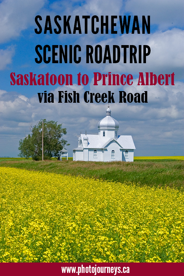
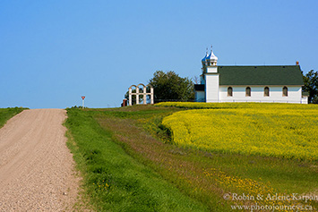
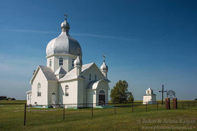
From Saskatoon, head northeast on Hwy #41 towards Aberdeen. Roughly 10 km past Aberdeen on Hwy #41, turn north where the sign indicates Fish Creek Road. Before long, the onion domes of two impressive Ukrainian churches loom on the eastern horizon. After just over 6 km, turn east on Smuts Road to Holy Trinity Ukrainian Greek Orthodox Church, dating to 1926, sitting alone among the grain fields. Continue another 2 km or so farther to the community of Smuts to see the even more imposing St. John the Baptist Church, dating to the same period. Both churches have been designated as heritage sites.
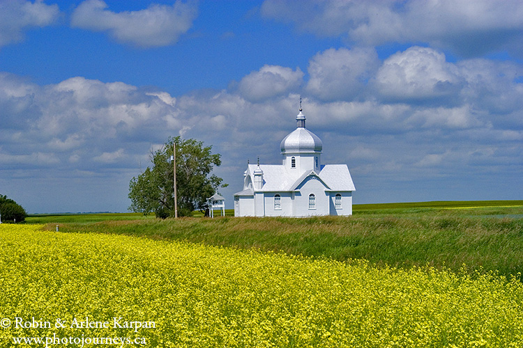
Back on Fish Creek Road, you pass the Ukrainian Catholic Church of the Ascension at Laniwci about 7 km farther north. Built in 1965, it’s a much newer church, but is noteworthy for its triple-arched bell tower.
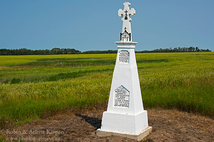
About 3 km north of this church, turn east at the Parks Canada sign. After 1.6 km (1 mile), head north again. At this corner, a monument written entirely in Ukrainian has a cross on top dedicated to “The Glory of God”. Built in 1917, it’s a testament to the religious life of that era.
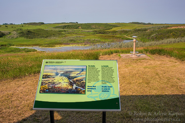
After 2 km or so, you cross the Fish Creek valley, then come to the cairn and plaque marking the site of Fish Creek National Historic Site and the Battle of Tourond’s Coulee that took place here on April 24, 1885 during the Northwest Rebellion, also referred to as the Northwest Resistance. Interpretive panels provide further details on the background of the engagement. Standing at the viewpoint overlooking the scenic and quiet coulee, it’s possible to visualize where the two sides met and how the fighting ensued.
This was the first engagement between Métis forces under Louis Riel and Gabriel Dumont, and the Canadian militia under General Middleton. Two months earlier near Duck Lake, Riel’s followers had a brief but deadly battle with North West Mounted Police and volunteers based at Fort Carlton. And now the militia was on the way. Dumont had set an ambush for the militia, but the element of surprise was lost when Middleton’s scouts discovered Dumont’s men concealed in the bushes. When the skirmish was over, the militia counted 10 dead and over 40 wounded; the Métis lost fewer men, but many of their horses were killed.
Continue north on the good gravel road that follows the riverbank much of the way, with excellent views over the valley, past some log buildings on old homesteads, and the imposing Fish Creek Church, not used since the 1950s and now boarded up.
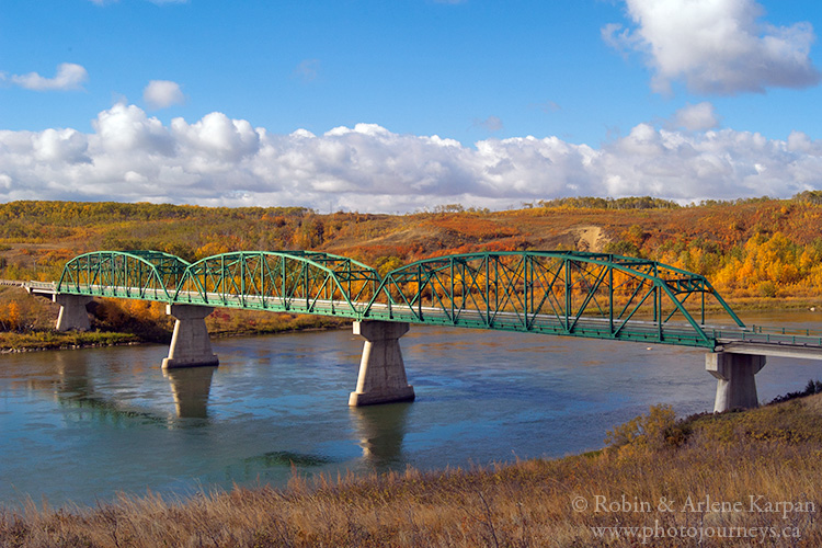
Fish Creek Road ends at Hwy #312, which runs between Wakaw to the east and Rosthern to the west. Just to the west is Gabriel’s Bridge, named for Gabriel Dumont who used to operate a ferry here. Cross the highway, and continue north on Hwy #225 to Batoche.
To Batoche
Along the 10-km drive to Batoche, you can still see some of the long, narrow river lots established by the Métis when they settled this area. How land was surveyed was one of the points of contention leading to the 1885 conflict. The government had been busily surveying the land into square mile sections, ignoring the river lots that the Métis were already using.
Batoche National Historic Site preserves the remains of the village of Batoche that was established here in 1872 where the overland fur trade route, the Carlton Trail, met the South Saskatchewan River. Today, Batoche depicts Métis culture and heritage, as well as the events surrounding the Battle of Batoche in May, 1885.
Two months earlier, Riel had declared Batoche as headquarters of a provisional government after the Canadian government delayed responding to his requests for reform. In response, the Canadian government mobilized the North West Field Force under General Middleton. The fighting at Batoche began on May 9, when Middleton sent the steamship Northcote towards Batoche to create a diversion, while his forces attacked from the south. Things didn’t go according to plan; the overland forces arrived late and the Northcote ran into the ferry cable which sheared off its smokestacks. Middleton’s troops advanced towards the village, burning houses and firing guns at the rectory. Over the next two days, fighting continued indecisively. By May 12, Riel’s forces were weakening and running out of ammunition. The militia was able to advance in a final assault that killed several Métis fighters.
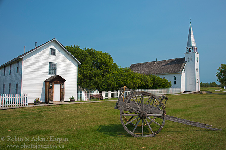
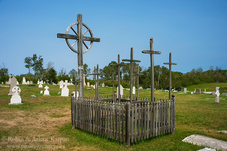
The Visitor Centre at Batoche sets the scene, with displays and a presentation that brings the culture and history alive. Guides take you through the Church of St. Antoine de Padoue and the rectory, both restored to 1896. In the cemetery, a monument commemorates those who died in the battles at Duck Lake, Fish Creek, and Batoche. Gabriel Dumont’s grave is near the riverbank, marked by a huge triangular-shaped boulder. Inside a picket fence nine crosses mark the mass grave where nine Métis killed in the final assault on Batoche are buried.
The ridges and trenches surrounding Middleton’s zareba (fortified encampment) are still visible, as well as rifle pits that the Métis used to defend Batoche. For a glimpse into Métis life, visit the former home of four generations of the Caron family. This house was rebuilt soon after the original home was destroyed during the battle.
There’s more to see just to the north of the main site at the East Village where foundations and cellars are all that remain from the original buildings of Batoche. You can walk to the riverbank and the site of the old ferry crossing where Xavier Letendre built his home, opened a store, and operated a ferry service.
North of the historic site on Hwy #225, you pass the large outdoor complex where Back to Batoche Days take place. This celebration features Métis culture and heritage with fiddling and jigging, sports events, artisan displays, and many other special programs.
To St. Laurent and St. Louis
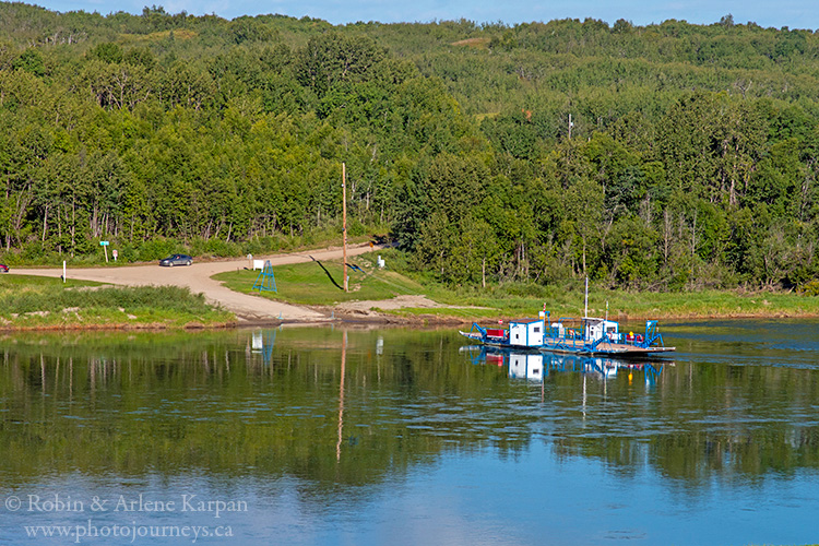
Just north of Batoche, Hwy #225 turns east towards Bellevue and Hwy #2, while road #782 goes north towards the St. Laurent Ferry and St. Louis. About 5 km along this road, you come to the turn-off to the St. Laurent Ferry (free service) that crosses the South Saskatchewan River. It’s a worthwhile detour to visit the historic and religious site of St. Laurent just across the river.
When you leave the ferry on the west side, take the right branch of the road for less than 1 km, and watch for the access road to St. Laurent on the right. Like Batoche, St. Laurent was an early Métis settlement, dating to the 1870s. Today it is also an important religious site where pilgrimages take place each summer in July and August.
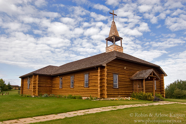
St. Laurent has a beautiful setting overlooking the river. The centrepiece of the site is a log church, built to replace the historic log church that burned in 1990. The religious significance of St. Laurent dates to 1879 when a shrine and grotto were erected in the hillside near a spring, a setting which a priest from France said reminded him of the Shrine of Our Lady of Lourdes in France. Fourteen years later, Brother Guillet, who had a crippled leg, made a pilgrimage to the shrine and was cured. Since then, it’s become an annual tradition for hundreds of people to make the pilgrimage to St. Laurent.
When you leave St. Laurent, the road from the ferry continues to Hwy #11. However, the more scenic route to Prince Albert is to take the ferry back to the east side of the river and continue north on road #782 to St. Louis.
Road #782 winds along the east riverbank much of the way through rolling farm land and thick bush. This stretch is especially nice during fall colour season. Along this road lies the site of one of the most important fur trade posts on the South Saskatchewan River—South Branch House. After driving about 7.5 km from the St. Laurent Ferry, watch for a small bridge over a culvert and creek. Just north of here is a trail heading west along the river. Only venture down the narrow trail in dry weather conditions. The road is not maintained and might not be passable in wet weather due to mud and deep ruts.
An historic sites marker indicates the former site of South Branch House. The plaque gives a short history of the Hudson’s Bay Company post that operated from 1786 to 1794. Among those who worked here was the soon-to-be-famous explorer and geographer David Thompson, who served as a clerk in 1786-87. Peter Fidler, who went on to be a prominent cartographer, did clerical duties as well from 1789-90. The post’s operation came to an abrupt end on June 24, 1794 when it was attacked by Gros Ventre who burned the fort, killed many inhabitants, and took others captive.
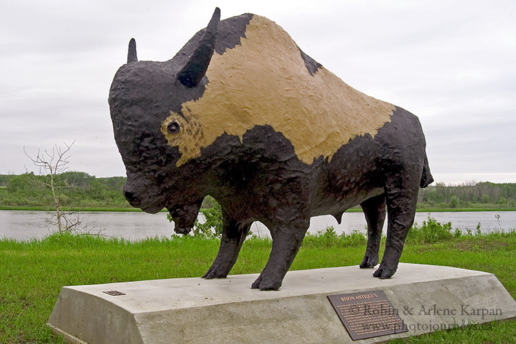
The road soon turns east and winds into St. Louis, about 17 km farther, becoming Riverside Drive. Sitting conspicuously beside St. Louis’ old bridge on the south side of the river is a statue of a prehistoric bison, built to commemorate a significant find nearby where archaeologists unearthed well-preserved bones and artifacts dating back more than 8,000 years. Most remarkable, the 9-foot-high, 13-foot-long creature is life-size—about 25% larger than bison today. Next to the statue, a large map shows points of interest in the area.
If you’re continuing to Prince Albert, keep going through St. Louis on Riverside Drive, then turn northeast onto Hwy #25 on the east side of town. This road meets Hwy #2, taking you across the South Saskatchewan River on a new bridge, and eventually on to Prince Albert.
For more details on this route, along with map and GPS coordinates, see Saskatchewan’s Best Scenic Drives. The popular guidebook also includes several other backroads driving routes throughout Saskatchewan.
SUBSCRIBE to Photojourneys below
Feel free to PIN this article