
Want to check out some of Saskatchewan’s most amazing landscapes but not expend a lot of effort getting there? Here are 5 of our favourite Bucket List worthy natural wonders from different parts of the province that are surprisingly easy to visit.
Nipekamew Sand Cliffs

Brilliant white cliffs and pillars, some as high as 23 metres, rise straight from the banks of the narrow Nipekamew River. Sediments deposited here over 120 million years ago have been eroded and exposed by the river to form one of Saskatchewan’s most unusual landscapes. These fragile formations have been sculpted into a variety of shapes and contours, from perfectly vertical flat-faced cliffs to oddly-shaped spires resembling abstract art.

The best news is that they are remarkably easy to visit. About 32 kilometres south of La Ronge, take Highway 165 east for around 22 km and turn onto the well-signed access road. A parking area has a panel with basic information on the cliffs. Head out on the pleasant walking trail that goes 1.3 kilometres through the forest to the Nipekamew River where you can look over a cliff on the opposite bank. Though the trail ends here, it is possible to walk further through the bush to see other cliffs, but walking will be more difficult. The formations are extremely fragile and should not be disturbed.
Read more about visiting the Nipekamew Sand Cliffs in our article Prince Albert to La Ronge Road Trip.
The Mysterious Crooked Bush

Trembling aspens are the dominant tree of Saskatchewan’s parklands, and for the most part, they all look fairly similar. Except here. In this small bush in the Thickwood Hills, the trees can’t decide if they should grow up, down, sideways or in spirals. Every branch, every trunk of every tree is twisted and contorted. Yet the trees in nearby bushes are perfectly normal. So what’s going on?
The story goes that many years ago a local fellow swore that he saw a flying saucer land here. All the passengers got out, peed on the ground, climbed back aboard, then flew off. The trees were never the same after that. This neck of the woods used to be famous for its homebrew, but that’s probably just a coincidence. Scientists have more mundane explanations involving genetic mutations and such. But we have to ask what caused the mutation in the first place? We like to think that it was spaceman pee.

This is the perfect place to marvel at the strange phenomenon, let your imagination run wild, and arrive at your own conclusions. The easiest way to visit is to drive along Highway 40 between Hafford and Speers, then follow the Crooked Bush signs north.
Read more about the Crooked Bush in our article Saskatchewan Road Trip to the Crooked Bush.
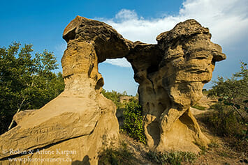
Hidden Conglomerate Cliffs – Cypress Hills

Most visitors to the West Block of Cypress Hills Interprovincial Park are familiar with the Conglomerate Cliffs, a stunning landscape that is easy to visit by simply following the road signs. But did you know that there is also a remote set of Hidden Conglomerate Cliffs that are just as spectacular, possibly more so because of the sweeping views over the seemingly endless forest? Yet many park visitors aren’t even aware of them.
Overlooking Battle Creek Valley, these cliffs are called hidden because, when we drive along the valley road, they are concealed behind trees. Despite their off-the-beaten-path location, the cliffs are fairly easy to visit. The most scenic approach is along the Trans Canada Trail (also known as the Great Trail). Drive west along Battle Creek Road to just short of the Alberta border, and watch for a trailhead across the road from an old log building (the only building anywhere in the vicinity). It’s a relatively short hike up to the valley rim where the trail passes the hidden cliffs jutting into the valley.
Read more about photography in the Cypress Hills here: 5 Top Photo Sites Cypress Hills West Block.
Fanciful Formations of Roche Percee

Roche Percee refers both to the name of the village and to a prominent rock formation on the edge of town. The hilltop outcrop once supported a large window-like hole, hence the French name “roche percée” meaning pierced rock. While the upper portion of this window has long since collapsed, the large grouping of easily-eroded sandstone formations is loaded with intriguing shapes, bridge-like formations, and smaller windows.
Over the years, the rock served as an important landmark for First Nations peoples, Mounted Police, surveyors, rumrunners, and settlers. The site was noted by the Palliser Expedition (1857-1860) and the International Boundary Commission. A cairn nearby commemorates Short Creek Camp, where the North West Mounted Police camped on their historic March West in 1874. Look closely to find names carved into the soft rock dating back well over a century.
Roche Percee is about 17 kilometres southeast of Estevan.
Read more about Roche Percee in our posting on Souris River Valley Road Trip
Dunes of the Great Sand Hills

The Great Sand Hills are home to the second-largest expanse of dunes in Canada; only the remote Athabasca Sand Dunes of Saskatchewan’s far north are larger. Fortunately, these southern dunes are so easy to visit that we can drive right up to them.
The best place to start a visit is in the village of Sceptre, about 20 kilometres east of Leader along Highway 32. Be sure to get oriented at the excellent Great Sandhills Museum, then head to the east side of town and follow the signs south for about 20 kilometres to the parking area right next to the massive hills of sand. Interpretive panels provide the lowdown on this fragile region, including the wildlife, how the hills were formed, and current land uses such as ranching. The ridge just behind is known as “Boot Hill”, with an eclectic mix of old cowboy boots attached to two posts and a cross-piece.

The first big dune is only a short stroll away, plus we can see others scattered in the distance. We soon enter an exotic world of wind-sculpted ripples, blowouts, and desiccated remnants of trees consumed by moving sand. This dry land can produce an amazing array of wildflowers. In early summer, brilliant red blossoms of sand dock bring splashes of colour to the dune edges.
Read more about visiting the Great Sand Hills.
Looking for More Information?
Find out more about these and other places to visit in Saskatchewan in the bestselling Great Saskatchewan Bucket List book, and order your copy, or contact your local bookstore.
SUBSCRIBE to Photojourneys below
Feel free to PIN this article
